Via alpina 2013 full movie & Via Alpina 2017


Allright folks the full via alpina Meet the locals 2013 movie has been published back in 2014 (41 minutes)..but i did not mentioned it… anyway here it is (ok the sound is shit but it is a really good movie). Enjoy


New post today to announce that there will be more alpine action on the Via alpina red and blue trail (and may be purple too) for me this coming summer 2017.

Already looking for a second hand Go Pro and a decent Mic to bring along and make an even more awesome movie about meeting the locals on the Via Alpina …

Life is good, the adventure never stops

Really looking forward to be back in the Alps

See you out there

Via Alpina 2013 video

Monaco – Trieste par la Via Alpina en 16minutes

sous titres en Français, captions in English

Cette vidéo pour donner un petit aperçu des rencontres que l’on peut faire sur la Via Alpina si l’on ouvre un peu les écoutilles 🙂

la Via Alpina est un itinéraire de Grande Randonnée accessible a tous. N’ayez pas peur et lancez vous dans cette belle aventure. Ajuster la durée en fonction de votre condition physique.

Merci au secrétariat de la Via Alpina d’avoir mis a disposition des informations précises et gratuites.

Hard to make a selection, full video is 40mins and might be released later on

This short video is showing a personal tiny piece of important moment or moment liked the most during the 76days journey across the Alps.

Grab your backpack and enjoy meeting the locals in the Alps…

Top 10 Favorite Via Alpina stages

Top 10 favorite Via Alpina stages during Via Alpina 2013 : Meet the locals

Verpeil Hutte – Braunschweiger Hutte Day 48 Otzaler Alps (off Via Alpina)

Val di Laur – Passo della Forchia Day 62 Val Pesarina

Rifugio Padova – Val di Laur Day 61 Val Montanaia/Postegae/Meluzzo Parco Dolomiti Friulane

Malga Oltreviso – Bivacco Casera del Mestri Day 65 Wild Friuli Carnia/Monte Sernio

Casera Canin – Bivacco Constantini Day 68 Val Resia/Monte Kanin (off Via Alpina)

Val di Tires – Alpe di Tires Day 55 Catinaccio/Rosengarten

Val di Fassa – Passo Pordoi Day 57 Marmolada

Rifugio Fedare – San Vito di Cadore Day 59 Mondeval

Modane – Refuge de la Valette Day 15 Vanoise (off Via Alpina)

Samoens – Lac de Salanfe Day 25 Swiss Valais

Via Alpina Favorite stages map

Via Alpina Favorite stages map

Things that I did not do but recommend to do

Mercantour : follow red Via Alpina trail in Vallée des Merveilles area (too much snow in early June 2013) R135 to R161

Queyras : Should have followed GR5 from Ceillac and catch up Briançon going through Queyras regional park, Via Alpina goes down too much in the valley and just passing by Ecrins… (R132 R131)

Avoiding Oberstdorf by going directly from Mindelheimer hutte to Kemptner hutte (R51, B40)

Explore more gruppo di Tessa area, Via Alpina stays low in the valley. More interesting variante called : Franz Huber steig in between Hausgang haus and Unser frau (B30 B29)

Things off Via Alpina that were good options

Going to Briançon and following GR5C to Nevache

Going up to Col de Chaviere and Pralognan la Vanoise in Vanoise national park rather than taking Via Alpina through Termignon

Avoiding Wenns and bus ride to Mittelberg by going to Verpeil Hutte (E5 variante), Cottbuser Hohenweg and Aperes Madatschjoch 3030m (2days extra)

Left Meraner Hohenweg and explore Gruppo di Tessa (lakes upper Hausgang Haus) but not enough exploration (missed Franz Huber steig)

Avoiding Tolmezzo and cutting short in between Monte Sernio and Monte Arvenis

Taking half day to reach monte Kanin, Alta Val Resia

Crossing Italian border (Via Alpina yellow trail makes sure you stays on the Italian side), leaving forest and entering Slovenia near Matajur. End or start trip at Matajur or reach Trieste on the Slovenian side making your own trail.

Stay tuned for upcoming release of video to resume this Via Alpina journey meeting the locals

Via Alpina Monaco – Trieste statistics

Below is the after Via Alpina Monaco – Trieste : Meet the locals journey extracted  statistics from the Via Alpina Day by day reporting

Via Alpina : Monaco – Trieste
2195km, 76 days,  550 hours walking up & down in the Alps meeting the locals

Average daily distance : 28,9km
Average daily walking time : 7:20
Average daily walking pace : 4km/h
Average daily resting time : 3:50
Longest stretch : 42,2km 09:35 Day 35 Meiringen – Engelberg (got pissed off the day before 🙂 )
Shortest stretch : 10km 03:10 Day 63 Passo della Forchia – Ovaro (got invited for lunch by locals)
Shortest resting time :  1:10 Day 23 rain all day
Longest resting time : 6:30 Day 57

Number of locals meet : >50

Alpine cheese tasted : >8 (Fontina, Tomme, Serac, Mutchli, Berner alpkase, Stafeli alpkase, Glarner alpkase, Montasio, etc…)

Pictures taken : > 4300 photos

Video recorded : hours and hours, lots of materials to make an upcoming documentary about Via alpina locals meet during that journey

Via Alpina 2013 Meet the locals hiking trail map

Via Alpina 2013 Meet the locals hiking trail map

Day Stage Distance Km Walk Time Rest Time Via Alpina stage Weather Date Bivouac type Price EUR Location
1 Monaco – Sospel 31 07:50 02:40 R161R160 sun 11th/06/13 sanitary block  sospel camping
2 Sospel – Bollene-Vesubie 33,7 08:10 04:05 D61 sun 12th/06/13 hut
3 Bollene-Vesubie – St Martin Vesubie 31 07:30 D59 D60 sun 13th/06/13 18 gite les champouns
4 St Martin Vesubie – Roure 26 07:10 D58 sun 14th/06/13 12 gite Roure
5 Roure – Roya 30,6 07:40 03:00 D57 D56 suncloud 15th/06/13 tent2
6 Roya – St Dalmas le Selvage 20 05:20 D55 sun 16th/06/13 18 gite Ph Issautier
7 St Dalmas Le Selvage – Larche 32 08:00 03:00 D54 D53 sun 17th/06/13 tent2 7,5 camping
8 Larche – Colle Del Maurin 27,7 07:50 03:40 D52 sun 18th/06/13 hut
9 Colle Del Maurin – Ceillac 19 05:00 R133 R134 sun 19th/06/13 17,5 gite les baladins
10 Ceillac – Mont Dauphin 36,9 08:30 02:25 R132 R131 sun 20th/06/13 16,5 gite glacier bleu
11 Mont Dauphin – Refuge de Pousterle 31 07:30 02:00 R130 sun 21st/06/13 tent2
12 Refuge de Pousterle – Briancon 27,5 06:00 03:20 off via alpina sun 22nd/06/13 16,8 gite petit phoque
13 Briancon – Col des Thures 33,6 08:30 02:30 off via alpina R127 sun 23rd/06/13 tent2
14 Col des Thures – Modane 28,2 06:30 02:10 R126 R125 snowsuncloud 24th/06/13 18,22 gite la sapinière
15 Modane – Refuge de la Valette 28,6 08:00 02:50 off via alpina sun 25th/06/13 13,7 refuge de la valette
16 Refuge de la Valette – Refuge de la Leisse 32,1 08:00 03:00 off via alpina, R123 sun 26th/06 12,5 refuge de la leisse
17 Refuge de la Leisse – Tignes Les Boisses 17,8 04:15 03:10 R122 lightrain 27th/06 21 Youth Hostel
18 Tignes Les Boisses – Valgrisenche 32,1 07:45 02:20 R121 R120 R119 suncloud 28th/06/13 Sheeperd Hut
19 Valgrisenche – Cerellaz 29,2 06:45 04:50 R118 suncloudlightrain 29th/06 25 Hotel des alpes
20 Cerellaz – Hospice du Col du Grand Saint Bernard 29,6 07:40 03:35 R117 sun 30th/06 18 Hospice du Grd St bernard 40CHF with supper
21 Hospice du Col du Grand Saint-Bernard – Champex 31,4 07:00 03:45 R116 R115 sun 1st/07 tent2
22 Champex – Les Montets 31,7 07:55 03:35 R114 R113 sun 2nd/07 tent2 7,8 camping Les montets
23 Les Montets – Refuge Moede Anterne 26,9 07:00 01:10 R112 lightrain 3rd/07 16 refuge Moede anterne
24 Refuge Moede Anterne – Samoens 28,1 06:30 03:15 R111 suncloudlightrain 4th/07 tent2
25 Samoens – Lac de Salanfe 33,3 08:40 04:25 R110 R109 sun 5th/07/13 chapel
26 Lac de Salanfe – Cabane Scex Carro 26,3 07:10 04:05 R108 R107 sun 6th/07/13 12 15CH cabane Scex Carro
27 Cabane Scex Carro – Pont de Nant 23,8 06:10 04:35 R106 sun 7th/07/13 20 25CH Auberge communal Pont de nant
28 Pont de Nant – Cabane du Prarochet 25,7 06:55 02:10 R105, off via alpina suncloud 8th/07/13 23 29CHF cabane du prarochet
29 Cabane du Prarochet – Lauenen 22,5 04:55 03:15 R104 R103 suncloudlightrain 9th/07/13 tent2hut
30 Lauenen – Adelboden 27,1 07:00 R102  C14 sun 10th/07 hut 15 18,1CHF camping albo
31 Adelboden – Oeschinensee 22 06:50 04:45 C13 sun 11th/07 huttent2
32 Oeschinensee – Lauterbrunnen 34 09:10 04:30 C12 C11 sun 12th/07 tent2 camping Lauterbrunnen
33 Lauterbrunnen – Grindelwald 20,5 05:50 04:20 C10 sun 13rd/07 tent2 private camping Grindelwald
34 Grindelwald – Meiringen 28,3 07:25 04:00 C9 sun 14th/07 tent2 13 16,5CHF alpen camping Meiringen
35 Meiringen – Engelberg 42,2 09:35 05:00 C8 sun 15th/07 tent2
36 Engelberg – Unterschachen 38,3 09:00 03:50 C7 sun 16th/07 tent2
37 Unterschachen – Linthal 22-30 07:00 02:40 C6 C5 suncloudlightrain 17th/07 tent2hut
38 Linthal – Elm 27,3 06:20 04:30 C4 sun 18th/07 tent2hut
39 Elm – Sargans 36,2 07:45 04:05 C3a C3b suncloudlightrain 19th/07 tent2
40 Sargans – Gafadura-Hutte 35,5 08:35 03:15 C2 R56 sun 20th/07 16 20CHF Gafadura hutte
41 Gadafura-Hutte – Blons 34,2 07:35 04:50 R55 sun 21st/07 tent2
42 Blons – Korbalpe Kapelle St Jakobus 39,8 09:15 04:15 R54 R53 sun 22nd/07 tent2
43 Korbalpe Kapelle St Jakobus – Oberstdorf 37 08:50 04:00 R52 R51 sun 23rd/07 tent2 camping platz Oberstdorf
44 Oberstdorf – Kemptner Hutte 16 03:15 00:40 B40 suncloudlightrain 24th/07 10 Kemptner Hutte
45 Kemptner Hutte – Memminger Hutte 33,7 07:20 02:30 B39 B38 sun 25th/07 10 Memminger Hutte
46 Memminger Hutte – Galflun Hutte 31,6 08:15 02:45 B37 B36 sunsuncloud 26th/07 18 Galflun Hutte
47 Galflun Hutte – Verpeil Hutte 27,4 07:20 02:00 off via alpina sun 27th/07/13 11 Verpeil Hutte
48 Verpeil Hutte – Braunschweiger Hutte 31,4 07:45 03:10 off via alpina, B35 sun 28th/07/13 9,5 Braunschweiger Hutte
49 Braunschweiger Hutte – Vent 35,3 08:00 03:00 B34 B33 lightrain 29th/07 21 Eberhard Haus
50 Vent – Karthaus/Certosa 32,1 07:45 02:50 B32 B31 sun 30th/07 tent2
51 Karthaus/Certosa – Hausgang Haus 29,1 07:50 04:00 B30 B29 sun 31st/07/13 tent2
52 Hausgang Haus – Merano 22,5 06:25 04:10 off via alpina, B28 sun 1st/08/13 tent2 14,5 camping Merano
53 Merano – Moltner meadow 28,1 06:45 02:50 B28 B27 sun 2nd/08 tent2
54 Moltner meadow – Val di Tires 35,6 07:20 06:00 B26 sun 3rd/08 tent2
55 Val di Tires – Alpe di Tires 26,4 07:10 03:45 B26 sunthunder 4th/08 tent2
56 Alpe di Tires – Val di Fassa 27,3 07:10 05:10 B25 B24 sun 5th/08 hut
57 Val di Fassa – Passo Pordoi 31 07:30 06:30 B23 B22 sun 6th/08 hut
58 Passo Pordoi – Rifugio Fedare 32,1 08:00 03:10 B21 sunsuncloud 7th/08 tent2
59 Rifugio Fedare – San Vito di Cadore 30,2 07:05 04:45 B20 B19 sun 8th/08/13 tent2
60 San Vito di Cadore – Rifugio Padova 35,4 08:20 03:55 B18 lightrainthunder 9th/08 12 rifugio Padova
61 Rifugio Padova – Val di Laur 29,1 08:45 02:55 B17 B16 sun 10th/08 tent2
62 Val di Laur – Passo della Forchia 30,2 07:25 03:20 B15 sun 11th/08 tent2
63 Passo della Forchia – Ovaro 10 03:10 B14 sun 12th/08 tent2 7 camping spin Ovaro
64 Ovaro – Malga Oltreviso 31,9 08:00 04:30 off via alpina, B13 sun 13th /08 tent2
65 Malga Oltreviso – Bivacco Casera del Mestri 20 05:15 02:25 B12 sunrain 14th/08 bivacco casera del mestri
66 Bivacco Casera del Mestri – Mucile 39 08:50 04:15 B11 sun 15th/08/13 tent2
67 Mucile – Casera Canin 24,4 06:30 04:35 B10 sun 16th/08/13 rifugiohut casera canin
68 Casera Canin – Bivacco Constantini 13,7 05:30 off via alpina, B10 sun 17th/08/13 bivacco bivacco Constantini
69 Bivacco Constantini – Montemaggiore 33,1 08:30 04:15 B10 B9 sun 18th/08/13 tent2
70 Montemaggiore – Staro Selo 28,3 06:45 B8,off via alpina sunthunder 19th/08 tent2
71 Staro Selo – Rifugio Pelizzo 14 04:25 B8,off via alpina lightrain 20th/08 12 rifugio Pelizzo
72 Rifugio Pelizzo – Varth 33,6 07:50 02:00 B7 sun 21st/08 hut
73 Varth – Dobrovo 36,7 08:30 03:20 B6, off via alpina sun 22nd/08 tent2
74 Dobrovo – San Martino del Carso 31,5 06:50 02:45 B5, off via alpina sun 23rd/08 couch
75 San Martino del Carso – Prosecco 34,1 07:35 04:20 B4 B3 sunthunder 24th/08 tent2
76 Prosecco – Muggia/Trieste 30,5 06:45 03:20 B2 B1 sunrainsuncloud 25th/08/13 couch
 in red uncollected data : numbers extracted from statistics/via alpina roadbooks 463 €
2195 550:10 233:20

Bivouac/Hut : Free accommodation (indoor & outdoor) : 45 nights out of 76

Gite/Rifugio/Hutte : Paid indoor accommodation : 26 nights out of 76
Bivouac/Camping : Paid outdoor accommodation : 5 nights out of 76

Via Alpina accomodation budget for 76 days out

Total accommodation budget : 463 Euros
Paid for 31 nights out of 76
Average budget for paid accommodation : 15 Euros

Via Alpina food budget : This can be very variable…on a trail or home you gotta eat anyway…nutrition is important to avoid getting injured

500-750euros/month is a reasonable food budget (personally close to 750euros but it includes eating at restaurants and not counting expenses for food/drinks)

All included (food + accommodation), via alpina hiking budget should be between 1000-1250euros/month out in the mountain
Simple tips to save money : no smoking, no alcohol and food expenses will stay low

Will now try to concentrate on making something out of the hours of recorded videos during that incredible via alpina journey

Try to compare the via alpina pre-itinerary and what was finally done

Detail location & suggest via alpina variantes/itineraries

Introduce my Top10 Via Alpina favorite stretches

Comments about the different via alpina routes (yellow trail, green trail, red and blue trail in France) that were hiked

Last but not least, will be to fill up the via alpina website (roadbook) with comments and pictures to help improve the via alpina information database

Thank you to all the following locals meet during that fantastic via alpina journey

JO @ Moulinet, Marcelle & Yann @ Roure, Manu @ Refuge de Longon, Auguste @ Saint Etienne de Tinee, Daniela @ Campo Base, Rosa @ refuge de Furfande, olivier & Laure @ gite Glacier Bleu Mont Dauphin, Cédric (L’odyssée Andine) @ Col de la vallée étroite, Paul @ Col de Chavière, Sylvie @ refuge de la valette, Louis, Céline and Hervé @ refuge de la leisse, Gaby @ Tignes le lac, Jean Louis @ Nantcruet, Max @ La combaz, Giulio & Mohammed @ alpage vallon St Grat, Enrico & Charles @ Col Citrin, Deborah (Walk the world for love) @ Col du Grand St Bernard, Marc @ Bourg Saint Pierre, Fabrice @ cabane Scex Carro, Jeremy, Marion and Jean Henri @ alpage L’au de l’arbignon, Stephan Junior, wife and kids, Stephan Senior and Heidi @ Bunderalp Adelboden, Hans and Patrick @ Ober Bergli, Kurt and wife @ Kleine Scheidegg alm, Tessa in Altdorf, Hans @ Gafadura Hutte, Simon and David in Blons, Franck and kids @ Obere Uberlutalpe, Lili and Alexander @ Hausgang Haus, Konrado @ Val Contrin, Giovanni and Gelando @ Casera mediana, Lorenzo and mama in Colza, Sylvano @ Malga dauda, Giovanni in Povici di Resiutta, Fiorella @ Santa Barbara chapel Val Resia, Federico and Marco @ Casera Canin, Valentino in Stupizza, Christina @ Dom Matajur, Emma, Robin and Lucia in San Martino del Carso

Any comment or feedback welcome, thank you

Day 76 : Prosecco – Muggia/Trieste 25th August 2013

Started this via alpina last day 7:20am.Rain came shortly after setting off last bivouac in the forest. Deer came close last night and saw 3 huge wild boars this morning.

Started the day with a quick laundry by the water spot

9:30am End of the napoleon road, entering Villa Opicina.Rifugio premuda marked 6h. Camping Obelisco right on the via alpina.CAI trail #1

10am 460m Monte Belvedere.Panorama over Trieste and Muggia

11:50am entered Bazzoni wood.

12:35am taking shortcut by steep way down on trail #49a.Via Alpina goes around Val Rosandra, feeling too tired to do extra kms today

1:20pm Rifugio Premuda

3:10pm leaving rifugio Mario Premuda, last rifugio on the via alpina…

5:20pm Muggia centro historico.Via alpina end up here but the adventure never stops…

Distance ; 30,5km

Walking : 6h45

Resting : 3h20

Weather : little rain in the morning, cloudy then sunny

Date ; Sunday 25th August 2013

image

Panorama on Trieste

image

image

Another Trieste panorama

image

image

Trieste

image

Val Rosandra

Muggia Church

Muggia Church

Day 75 : San Martino del Carso – Prosecco 24th August 2013

Leaving 7:45am friendly host Lucia and San Martino del Carso.
Jamiano marked 4h on trail #72

9:20am Lago di Doberdo

10:10am Jamiano.Restaurant and also B&B called villa al bosco by the main road

From Jamiano to Medeazza followed trail #3

11:10am Medeazza stopped for lunch to eat local ham called prosciutto crudo and local Teran  vino rosso.

12am leaving Medeazza on trail 3a.Sea 500m away

1:40pm Sea side trail near Duino

2:30pm Out of Sistiana..

After quick refreshing bath in the salty water reached Santa Croce 5pm 230m, now following last CAI sentiero #1

5:30pm 300m high point view on Trieste and Muggia

7:25pm just in time before the Prosecco town grocery store closing time.
Walking back to monasterio di san cipriano to look for accomodation…

Huge fence,no bell,impossible to get in…will go for a last pitch on the via alpina yellow trail in the nearby forest

Distance : 34,1km
Walking : 7h35
Resting : 4h20
Altitude : 260m
Weather : hot & sunny
Date : Saturday 24th August 2013

image

Lago di Doberdo

image

Prosciutto crudo

image

Sea view near Duino castle

image

Sistiana

image

Going vertical on Duino’s cliff

image

Trail #1 last or first via alpina yellow trail

image

Day 74 : Dobrovo – San Martino del Carso 23rd August 2013

Leaving Dobrovo 7:15am.Will try to find a way through Goriska Brda region vineyards to catch up via alpina

7:40am saw a beautiful fox in the vineyard

8:10am 180m Kozana

9am 230m Gorenje Cerovo

10:30am 240m Back in Italia and on the via alpina in Sovenza – San Floriano del Collio

11:45am 80m Crossing Fiume Isonzo on bridge, entering Gorizia town

2:45pm Out of ugly Gorizia town the worst possible way…going through industrial zone (now in the process of making cycling/walking path).Don’t know where the trails are if they are some…

3:15pm Savogna d’isonzo

3:30pm Rubbia.San Martino del Carso marked 2h on trail #73

Had to pass over a locked 1,5m high fence on this sentiero that goes around a vineyard.

4:20pm many trails intersection.Right/West trail smic010d

Staying right/west,leaving trail smic014z going left

Reached 250m

5pm San Martino del Carso. Lucia & Dorothea 3years old welcomed me in the house, via vicenza 9 as read in the via alpina roadbook.
Warm indoor couch available with clean sheets and pillow, hot shower and a great encounter with artist Lucia

Distance : 31,5km
Walking : 6h50
Resting : 2h45
Weather : hot & sunny
Date : Friday 23rd August 2013

Went to assist 7pm messa.One woman came talking to me while sitted..asked me if the messa was on because a sign said there was no messa today….

No mass today, the priest came and told me and the woman to go home…allright can still stay inside chilling

Lucia told me that the priest is 92years old and still drive a car in the neighborhood…

image

Sunset other Dobrovo – Slovenia

image

Goriska Brda countryside

image

Goriska Brda vineyards

image

Gorizia

image

Gorizia via alpina way marker

image

Rubbia

image

San Martino del Carso church

Day 73 : Varth – Dobrovo 22nd August 2013

Leaving the hunters house 6:45am

7:25am 700m Locked chapel.Castelmonte marked 2h35 on trail #747

8:15am 660m near locked Chiesa di San Nicolo. Another opened hunters house.fireplace,table,chairs and couches but untaken care of…Door was opened wide and lots of garbages inside.

9:50am 618m Sanctuario di Madonna di Monte/Castelmonte

No short pant or t shirt inside the sanctuario, needed to put the rain gear on to get it 🙂

10am mass in progress.Beautiful sanctuario.
In the crypt many drawings/paintings representing car accidents…people who escaped accidents pay tribute to madonna di monte

10:50am leaving Castelmonte on trail #748.Via alpina roadbook says 15km to Gorizia while GPS and hikers comments suggests 48km (straight..probably more following via alpina trail)

Finally getting out forest,vineyards appears..

1:30pm 135m The grapes in the vineyard near Albana are ready to be eaten.Stopping by for a quick grape feast

1:50pm leaving Albana, entering provincia di Gorizia

2pm decide to get off the via alpina yellow trail and get on the slovenian side for the night…should also be shorter to reach Gorizia…feeling that it goes backward or often in the wrong direction when following via alpina trail #748 since Castelmonte.

Get in Slovenia around 4pm…moving along the vineyards and cute villages on top of the hills.

Crashed in Dobrovo town..arrived there around 6pm…will pitch in the nearby small forest tonight

Today was a hard day…finally got off the forest and getting some visibility..the via alpina roadbook information for this stage (gorizia-castelmonte) is incorrect and approximative..

Luckily the expected bad weather is delayed to sunday..was predicted for tomorrow…should be Trieste then

Distance : 36,7km
Walking : 8h30
Resting : 3h20
Altitude : 140m
Date : Thursday 22nd August 2013
Weather : very hot & sunny

image

Matajur

image

Hunters house near San nicolo

image

Young goat keepers

image

Castelmonte first view

image

Inside Sanctuario madonna di monte

image

Virgin with kid

image

Grapes & vineyards in Albana

image

Slovenian religious statue

image

Slovenian vineyard – Goriska Brda region

image

Slovenian – Goriska Brda tasty peaches

image

Dobrovo – Goriska Brda

Day 72 : Rifugio Pelizzo – Varth 21st August 2013

Leaving the comfort of rifugio Pelizzo 7:50am

Going down trail #736 towards Cepletischis

9:05am 910m Opened hut, stone walls and roof

9:45am 558m Cepletischis.Mobile alimentari/grocery truck only on wednesday (probably only morning)

10am 500m Torrente Rieca low point on trail #745 towards Topolo

10:30am 810m.Bivacco Zanuso marked 2h50.Rifugio Solarie marked 3h35

10:50am 590m Topolo.Meet and talked to few locals from France & Belgium.Told me the Dalai Lama came to Povala (village near Cepletischis at slovenian border) last year.Saw a house with Tibetan prayer flags.Via alpina passing right next to this holy buddhist place.Few lamas are staying there.Surely worth stopping by and definitely a possible accommodation…

11:25am 650m Opened hut called Gostilna Seuje.Roof and stone walls

12am 760m Lase hamlet out of the woods.Little bit of fresh air and view here

12:45am 1145m after steep trail up.Via alpina connects with road.View on Matajur,Topolo and flat land.

1pm 1100m Bivacco Zanuso.Lots of people and cars (road just nearby),seems open,nice view.

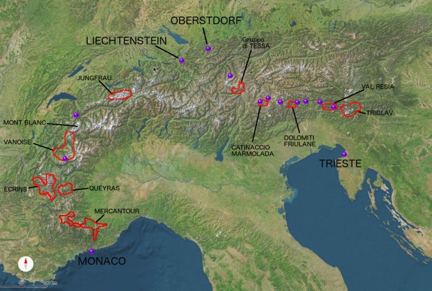
Sentiero della Pace is taking the nearby ridge on the border linr between Slovenia and Italy

1:25pm 956m Rifugio Casoni Solarie.

2:15pm leaving rifugio Casoni Solari after lunch break.Local via alpina sign tells Castelmonte 5h15.Via alpina roadbook says 5h30.Castelmonte might be reachable today…

2:30pm 800m Clabuzzaro.According to GPS device there is a restaurant in Clabuzzaro

Just saw time marker saying Castelmonte 6h50…not helping boosting moral but probably incorrect.Monte Cum marked 1h45 on trail #747

3pm San Volfango WW1 cemetary.Natisone valley great war action where 500 italians died here during the conflict.

3:50pm 890m In the forest.Opened rustic hunter shack with fireplace.

4pm 912m Monte Cum high point in the forest with no visibility.Not mentionned in via alpina roadbook.

4:25pm 640m Passing nearby San Giovanni

4:40pm 605m Gridovizza hamlet.Via alpina still on the Alpe Adria trail.

5pm 570m Passing nearby Clunaz

5:10pm 610m Big hut nearby via alpina,big outside roof,tables and benches..oh yeah it is open… Naked girls and wild boars posters, pictures of men smilling by the side of dead wild animals…yep that is right…local hunters shack without the hunters 🙂

Too tempting to carry on…cooking gear,fireplace,little food and drinks on the house (Squadra Cacciatori Stregna)…wouhouuuu

5:30pm Found the gas tank…hot coffee scheduled for tomorrow morning

Distance : 33,6km
Walking : 7h50
Resting : 2h
Weather : sunny
Altitude : 610m
Date : Wednesday 21st August 2013

Spent most day again in forest with again almost no visibility…

Could have been harder on a rainy day,lots of ups and downs.Been mostly in the forest since almost a week now…no more real mountain (except off via alpina half day to Monte Kanin on day 68) on the via alpina that almost follows the border line with Slovenia since a long time (without crossing it)

Great view from nearby hunter shack hill on Slovenian mountains

7pm Funny, deer approached about 100m away from the hunters shack…

7:30pm Found some corn and a hunting map…Hunters here uses corn has a bait..the map in the shack shows the corn dropping/killing spots.

Took some corn and throw it 50m away from the shack and within 30mins…2 Capriolos came in for the picture 🙂

image
View of rifugio Pelizzo and the flat land

image

Panorama Matajur and rifugio Pelizzo

image

Matajur view on the way to bivacco Zanuso

image

Via alpina forest trail

image
San Volfango WW1 & WW2 memorial

image

Varth hunters house

image

Capriolo’s coming for dinner

Day 71 : Staro Selo – Rifugio Pelizzo 20th August 2013

6:30am packing stuff to find a roof.Rain and strong wind blowed during the night.Roughest night so far and the worst is that it looks like the weather gonna stay like this all day…

7am Svino area, stopped by the 1st founded roof. Started falling asleep while seated…lied down and took a morning nap

8:45am moving up to Monte Matajur from Svino in the woods until 1200m

12:10am 1500m flat land view and whaaaaat? Reallllyyyy!!! Sea view…wouhouuuu…

12:30am 1641m Monte Matajur Chapel.Open there and glad it is because the strong wind and rain make it hard to stay outside.

1:30pm moving down to rifugio Dom Matajur.Great view from there.

Someone there it is open and warm inside.Christina cutted some cheese and salami then cooked me a pasta shoot…wouhou..electricity here and lots of food available.

Went for a siesta and slept few hours.
Around 5:40pm been told that had to go to rifugio Pelizzo.Christina was going down and locking the rifugio Dom Matajur…late surprise..been told that the Dom Matajur rifugio opened week ends and only if booked ahead…

Walked down rifugio Pelizzo at got there before 7pm 1300m

Great sea view and the flat land.Spotted Muggia bay with the rifugio binoculars… Seaweed smell? Not yet

No one there tonight..only me for this 40 beds capacity refuge.12euros for the bed.Expensive Hot shower at 5euros.
The pasta and food are all made on site. 6euros for a huge breakfast

Distance : 14km
Walking : 4h25
Weather : cloudy and light rain most day, cold and very windy at Monte Matajur
Date : Tuesday 20th August 2013

image

On the way up Matajur from Slovenia…Dense forest from 400m up to 1200m

image

1200m on the way to Matajur

image
Chapel at Monte Matajur

image
Panorama at rifugio Dom Matajur

image

Fresh pasta made at rifugio Pelizzo